Search Constraints
You searched for:
Format
GeoTIFF
Remove constraint Format: GeoTIFF
Place
Balkanhalbinsel
Remove constraint Place: Balkanhalbinsel
Publication Year
1918
Remove constraint Publication Year: 1918
« Previous |
1 - 10 of 12
|
Next »
Search Results
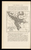
1. Carte de la Péninsule des Balkans
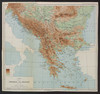
1918. Balkanhalbinsel and Südosteuropa. Versteckte Karten.
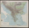
2. Carte ethnographique de la péninsule des Balkans
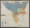
1918. Balkanhalbinsel and Südosteuropa. Ethnische Gruppe. Ethnografie. Versteckte Karten.
3. Courants métanastasiques dans le peuplement des pays Serbes du XVe siècle à nos jours
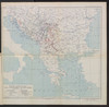
1918. Balkanhalbinsel and Südosteuropa. Migration. Migration. Versteckte Karten.
4. Formes de la propriété rurale
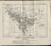
1918. Balkanhalbinsel and Südosteuropa. Grundeigentum. Versteckte Karten.
5. La chaîne centrale d'après Ptolémée

1918. Balkanhalbinsel and Südosteuropa. Geografie and Ptolemaeus, Claudius. Versteckte Karten.
6. Libération et agrandissements successifs des états Balkaniques

1918. Balkanhalbinsel and Südosteuropa. Unabhängigkeitsbewegung. Versteckte Karten.
7. Remparts montagneux et morcellement du relief en župa
1918. Balkanhalbinsel and Südosteuropa. Geografie. Versteckte Karten.
8. Types des maisons

1918. Balkanhalbinsel and Südosteuropa. Haus. Versteckte Karten.
9. Types des villages

1918. Balkanhalbinsel and Südosteuropa. Ländliche Siedlung. Versteckte Karten.
10. Types et variétés psychiques des Yougoslaves
1918. Balkanhalbinsel and Südosteuropa. Ethnische Gruppe. Ethnografie. Versteckte Karten.