Search Constraints
You searched for:
Format
GeoTIFF
Remove constraint Format: GeoTIFF
Subject
Umland
Remove constraint Subject: Umland
Map Type
Topografische Karte
Remove constraint Map Type: Topografische Karte
« Previous |
1 - 10 of 26
|
Next »
Search Results
1. [Grenzgebiet der Gespanschaft Split-Dalmatien ; Höhentabelle]
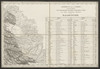
1869. Kroatien, Dalmatien, and Bezirk Split-Dalmatien. Umland. 1869/1869. Versteckte Karten.
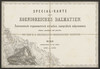
2. [Kanal von Brač]

1869. Kroatien, Dalmatien, and Brač. Umland. 1869/1869. Versteckte Karten.
3. [Kanal von Korčula]

1869. Kroatien, Dalmatien, and Korčula. Umland. 1869/1869. Versteckte Karten.
4. [Lastovo]

1869. Kroatien, Dalmatien, and Lastovo. Umland. 1869/1869. Versteckte Karten.
5. [Nebenkarte Palagruža zu Lastovo]

1869. Kroatien, Dalmatien, and Palagruža. Umland. 1869/1869. Versteckte Karten.
6. [Nebenkarte Svetac zur Umgebung von Šolta]

1869. Kroatien, Dalmatien, and Šolta. Umland. 1869/1869. Versteckte Karten.
7. Okrestnosti g. Tuly i verchnee tečenīe r. Upy

1902. Russland, Zentralrussland, and Tula. Umland. Versteckte Karten.
8. Okrestnosti S. Peterburga
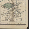
1900. Il'in', N. Russland and St. Petersburg. Umland.
9. [Umgebung von Žirje]

1869. Kroatien, Dalmatien, and Žirje. Umland. 1869/1869. Versteckte Karten.
10. [Umgebung von Dragalj, Montenegro ; Titel]
1869. Montenegro and Orjen. Umland. 1869/1869. Versteckte Karten.
- « Previous
- Next »
- 1
- 2
- 3