Search Constraints
You searched for:
Access
Public
Remove constraint Access: Public
Map Type
Topografische Karte
Remove constraint Map Type: Topografische Karte
Map Scale
900000
Remove constraint Map Scale: 900000
1 - 3 of 3
Search Results
1. Die adriatische Küste von Pola bis Zara
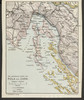
1913. Kroatien and Adriaküste <Nord>. Versteckte Karten.
2. Die adriatische Küste von Spalato bis Cattaro
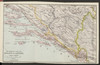
1913. Kroatien and Adriaküste <Süd>. Versteckte Karten.
3. Die adriatische Küste von Zara bis Spalato

1913. Kroatien and Adriaküste <Süd>. Versteckte Karten.