Search Constraints
You searched for:
Place
Albanien
Remove constraint Place: Albanien
Subject
Ethnische Gruppe
Remove constraint Subject: Ethnische Gruppe
1 - 7 of 7
Search Results
1. Albanie (Races et Religions)
1915. Albanien. Ethnische Gruppe and Denomination <Religion>. 1915/1915. Ethnografie. Versteckte Karten.
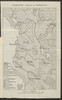
2. Map 56 : Sketch map on the ethnic distribution of the population in Albania (cca. 1912)
2021. Demeter, Gábor and Bottlik, Zsolt. Vilâyet Yanya and Albanien. Ethnische Gruppe. 1910/1910. Ethnografie. Versteckte Karten.
3. Map 57 : The boundaries and ethnic contact zone of the Albanian nation (Ottoman version, 1908)
2021. Demeter, Gábor and Bottlik, Zsolt. Albanien, Kosovo, and Nordmazdonien. Ethnische Gruppe and Grenzgebiet. 1908/1908. Ethnografie. Versteckte Karten.
4. Map 58 : The boundaries and ethnic contact zone of the Albanian nation (Austria-Hungary, 1917)
2021. Demeter, Gábor and Bottlik, Zsolt. Albanien, Kosovo, and Nordmazdonien. Ethnische Gruppe and Grenzgebiet. 1917/1917. Ethnografie. Versteckte Karten.
5. Map 59 : The boundaries and ethnic contact zone of the Albanian nation (Bulgarian version, 1918)
2021. Demeter, Gábor and Bottlik, Zsolt. Albanien, Kosovo, and Nordmazdonien. Ethnische Gruppe and Grenzgebiet. 1918/1918. Ethnografie. Versteckte Karten.
6. Map 60 : Ethnographic data on Albania and the sanjak of Novipazar according to Roukis (1884)
2021. Demeter, Gábor and Bottlik, Zsolt. Albanien and Sandschak Novi Pazar. Ethnische Gruppe. 1884/1884. Ethnografie. Versteckte Karten.
7. Map 9 : The ethnic map of Chekrezi, on the southern border of Albania, in 1913
2021. Demeter, Gábor and Bottlik, Zsolt. Albanien, Griechenland, and Nordmazedonien. Ethnische Gruppe and Çekrezi, Kostë A. 1913/1913. Ethnografie. Versteckte Karten.