Search Constraints
You searched for:
Place
Balkanhalbinsel
Remove constraint Place: Balkanhalbinsel
Map Type
Altkarte
Remove constraint Map Type: Altkarte
1 - 6 of 6
Search Results
1. Charte von der europaeischen Tuerkey von Griechenland und den Ionischen Inseln
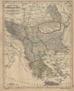
1843. Balkanhalbinsel, Osmanisches Reich, and Griechenland. Versteckte Karten.
2. Dacia, Moesia, Illyris Graeca, Macedonia et Thracia
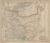
1843. Balkanhalbinsel and Römisches Reich. Verwaltungsgliederung. Versteckte Karten.
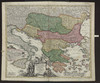
3. Danubii fluminis (hic ab urbe Belgrado, per Mare Nigrum usq Constantinopolim defluentis exhibiti) pars infima, in qua Transylvania, Walachia, Moldavia, Bulgaria, Servia, Romania et Bessarabia cum vicinis regionibus ostenduntur
1730. Homann, Johann Baptist . Balkanhalbinsel and Donau. Flusslauf.
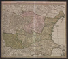
4. Fluviorum in Europa principis Danubii Cum Adiacentibus Regnis, nec non totius Graeciae Et Archipelagi Novißima Tabula
Homann, Johann Baptist . Balkanhalbinsel and Donau. Flusslauf.
5. La chaîne centrale d'après Ptolémée

1918. Balkanhalbinsel and Südosteuropa. Geografie and Ptolemaeus, Claudius. Versteckte Karten.
6. Voenno-dorožnaja karta časti Rossii i pograničnych zemelʹ

Šubert. Balkanhalbinsel and Osmanisches Reich.