Search Constraints
You searched for:
Place
Balkanhalbinsel
Remove constraint Place: Balkanhalbinsel
Map Type
Bevölkerungskarte
Remove constraint Map Type: Bevölkerungskarte
« Previous |
1 - 10 of 11
|
Next »
Search Results
1. Carte ethnographique de la péninsule des Balkans
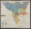
1918. Balkanhalbinsel and Südosteuropa. Ethnische Gruppe. Ethnografie. Versteckte Karten.
2. Courants métanastasiques dans le peuplement des pays Serbes du XVe siècle à nos jours
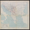
1918. Balkanhalbinsel and Südosteuropa. Migration. Migration. Versteckte Karten.
3. Italien und Balkanhalbinsel. Nebenkarten I. 1 Völker
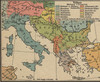
1912. Balkanhalbinsel and Italien. ethnische Gruppe. Ethnografie. Versteckte Karten.
4. Italien und Balkanhalbinsel. Nebenkarten I. 1 Volksdichte
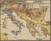
1912. Balkanhalbinsel and Italien. Bevölkerungsdichte. Versteckte Karten.
5. Map 6 : A simplified ethnic map of the Balkans for Hungarian military officers
2021. Demeter, Gábor and Bottlik, Zsolt. Balkanhalbinsel. Ethnische Gruppe. 1913/1913. Ethnografie. Versteckte Karten.
6. Map 61 : Ethnic map of the Balkans in 1910 (based on Ottoman salname)
2021. Demeter, Gábor and Bottlik, Zsolt. Balkanhalbinsel. Ethnische Gruppe. 1910/1910. Ethnografie. Versteckte Karten.
7. Map 8 : a simplified sketch map of the evolution of Cvijic’s ideas
2021. Demeter, Gábor and Bottlik, Zsolt. Balkanhalbinsel. Ethnische Gruppe and Cvijić, Jovan. Ethnografie. Versteckte Karten.
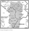
8. Siedlungsgebiet der Albaner
1982. Balkanhalbinsel. Albaner and Siedlung. 1982/1982. Ethnografie. Versteckte Karten.
9. Types et variétés psychiques des Yougoslaves
1918. Balkanhalbinsel and Südosteuropa. Ethnische Gruppe. Ethnografie. Versteckte Karten.
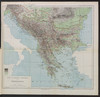
10. Völkerkarte

1913. Balkanhalbinsel. Ethnische Gruppe. Ethnografie. Versteckte Karten.