Search Constraints
You searched for:
Place
Balkanhalbinsel
Remove constraint Place: Balkanhalbinsel
Project
GeoPortOst
Remove constraint Project: GeoPortOst
Map Scale
Unknown
Remove constraint Map Scale: Unknown
« Previous |
1 - 10 of 12
|
Next »
Search Results
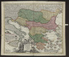
1. Danubii fluminis (hic ab urbe Belgrado, per Mare Nigrum usq Constantinopolim defluentis exhibiti) pars infima, in qua Transylvania, Walachia, Moldavia, Bulgaria, Servia, Romania et Bessarabia cum vicinis regionibus ostenduntur
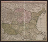
1730. Homann, Johann Baptist . Balkanhalbinsel and Donau. Flusslauf.
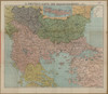
2. Die Balkanländer im Jahre 1876
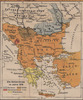
1919. Balkanhalbinsel. 1876/1876. Versteckte Karten.
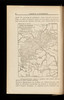
3. Die Balkanländer im Jahre 1912
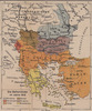
1919. Balkanhalbinsel. 1912/1912. Versteckte Karten.
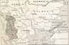
4. Die Balkanländer im Jahre 1914
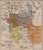
1919. Balkanhalbinsel. 1914/1914. Versteckte Karten.
5. Fluviorum in Europa principis Danubii Cum Adiacentibus Regnis, nec non totius Graeciae Et Archipelagi Novißima Tabula
Homann, Johann Baptist . Balkanhalbinsel and Donau. Flusslauf.
6. G. Freytags Karte des Kriegsschauplatzes auf der Balkanhalbinsel
1917. Balkanhalbinsel and Osmanisches Reich. 1912/1912.
7. La chaîne centrale d'après Ptolémée

1918. Balkanhalbinsel and Südosteuropa. Geografie and Ptolemaeus, Claudius. Versteckte Karten.
8. Ligne de partage d'après la carte annexée au traité d'alliance
1917. Balkanhalbinsel. Grenze and Balkankrieg <1912-1913>. 1912/1913. Versteckte Karten.
9. Modifications territoriales dans le Balkans: Conférence de Londres ; Traité de Bukarest
1914. Balkanhalbinsel. Bukarest / Friede <1913> and Staatsgrenze. 1913/1913. Versteckte Karten.
10. Modifications territoriales dans le Balkans: Traité de Bukarest
1914. Balkanhalbinsel. Bukarest / Friede <1913>. 1913/1913. Versteckte Karten.