Search Constraints
You searched for:
Place
Balkanhalbinsel
Remove constraint Place: Balkanhalbinsel
Project
GeoPortOst
Remove constraint Project: GeoPortOst
« Previous |
1 - 10 of 34
|
Next »
Search Results
1. Die Balkanländer im Jahre 1876
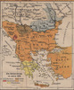
1919. Balkanhalbinsel. 1876/1876. Versteckte Karten.
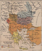
2. Map 4 : The plan of Calice (Austrian ambassador to Constantinople) from 1896
2021. Demeter, Gábor and Bottlik, Zsolt. Balkanhalbinsel. Großmachtpolitik and Calice, Heinrich von. 1896/1896. Ethnografie. Versteckte Karten.
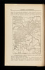
3. Map 61 : Ethnic map of the Balkans in 1910 (based on Ottoman salname)
2021. Demeter, Gábor and Bottlik, Zsolt. Balkanhalbinsel. Ethnische Gruppe. 1910/1910. Ethnografie. Versteckte Karten.
4. Map 7 : The linguistic map of Belić in the Balkans
2021. Demeter, Gábor and Bottlik, Zsolt. Balkanhalbinsel. Dialekt and Belić, Aleksandar. 1910/1910. Ethnografie. Versteckte Karten.
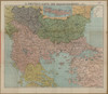
5. Die Balkanländer im Jahre 1912
1919. Balkanhalbinsel. 1912/1912. Versteckte Karten.
6. G. Freytags Karte des Kriegsschauplatzes auf der Balkanhalbinsel
1917. Balkanhalbinsel and Osmanisches Reich. 1912/1912.
7. Ligne de partage d'après la carte annexée au traité d'alliance
1917. Balkanhalbinsel. Grenze and Balkankrieg <1912-1913>. 1912/1913. Versteckte Karten.
8. Schematičeska karta na M. Dehn
1917. Balkanhalbinsel. Grenze and Balkankrieg <1912-1913>. 1912/1913. Versteckte Karten.
9. Balkanstaaten
1913. Balkanhalbinsel. Eisenbahnnetz. 1913/1913. Eisenbahn. Versteckte Karten.
10. Map 6 : A simplified ethnic map of the Balkans for Hungarian military officers
2021. Demeter, Gábor and Bottlik, Zsolt. Balkanhalbinsel. Ethnische Gruppe. 1913/1913. Ethnografie. Versteckte Karten.
- « Previous
- Next »
- 1
- 2
- 3
- 4