Search Constraints
You searched for:
Place
Deutsches Reich
Remove constraint Place: Deutsches Reich
Map Type
Geschichtskarte
Remove constraint Map Type: Geschichtskarte
Project
GeoPortOst
Remove constraint Project: GeoPortOst
1 entry found
Search Results
1. Zachodnie granice Niemiec
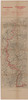
1920. Wierzbicki, B. Deutschland, Frankreich, and Deutsches Reich. Grenze. 1919/1919. Versteckte Karten.