Search Constraints
You searched for:
Place
Deutschland
Remove constraint Place: Deutschland
Map Type
Geschichtskarte
Remove constraint Map Type: Geschichtskarte
Project
IEG-Maps
Remove constraint Project: IEG-Maps
« Previous |
1 - 10 of 66
|
Next »
Search Results
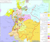
1. Besatzungszonen und Länder 1947
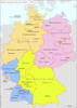
2004. Kunz, Andreas and Moeschl, Joachim Robert. Deutschland. Besatzungszone. 1947/1947.
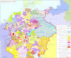
2. Der Deutsche Bund nach dem Frankfurter Territorialrezess um 1820
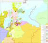
2004. Hundt, Michael. Deutschland. 1820/1820.
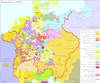
3. Deutschland 1555

2008. Kunz, Andreas and Moeschl, Joachim Robert. Deutschland. 1555/1555.
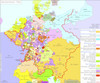
4. Deutschland 1648
2008. Kunz, Andreas and Moeschl, Joachim Robert. Deutschland. 1648/1648.
5. Deutschland 1792
2014. Kunz, Andreas and Moeschl, Joachim Robert. Deutschland. 1792/1792.
6. Deutschland 1803 nach dem Reichsdeputationshauptschluss
2014. Kunz, Andreas and Moeschl, Joachim Robert. Deutschland. Reichsdeputationshauptschluss. 1803/1803.
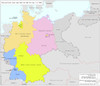
7. Deutschland nach dem Ersten Weltkrieg Ende 1921
2001. Kunz, Andreas and Moeschl, Joachim Robert. Deutschland. 1921/1921.
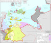
8. Deutschland nach dem Zweiten Weltkrieg 1.9.1945
2004. Kunz, Andreas and Moeschl, Joachim Robert. Deutschland. 1945/1945.
9. Deutschland um 1378
2009. Kunz, Andreas and Moeschl, Joachim Robert. Deutschland. 1378/1378.
10. Deutschland um 1500
2008. Kunz, Andreas and Moeschl, Joachim Robert. Deutschland. 1500/1500.