Search Constraints
You searched for:
Place
Russland
Remove constraint Place: Russland
Data Type
Raster
Remove constraint Data Type: Raster
Search Results
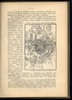
151. Plan osady Achul'go
1911. Russland, Dagestan, and Ashil'ta. 1839/1839. Versteckte Karten.
152. Plan sraženija pri Krasnom , 5 nojabrja
1911. Russland and Krasnoj. Russlandfeldzug <1812>. 1812/1812. Militärgeschichte. Versteckte Karten.
153. Plan sraženija pri Malojaroslavcě
1911. Russland and Malojaroslavec. Russlandfeldzug <1812>. 1812/1812. Militärgeschichte.
154. Plan sraženīja pri Borodině
1911. Russland and Borodino. Napoleonische Kriege and Schlacht bei Borodino. 1812/1812. Militärgeschichte.
155. Plan sraženīja pri Smolensk, 5 avgusta.
1911. Russland and Smolensk. Napoleonische Kriege. 1812/1812. Militärgeschichte. Versteckte Karten.
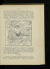
156. Plemena ozernoj oblasti
1900. Stavrovskij, Ja. Russland and Russland (Nord). Ethnische Gruppe. Ethnografie. Versteckte Karten.
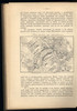
157. Plemena srednerusskoj černozemnoj oblasti
1902. Russland and Zentralrussland. Ethnische Gruppe. Ethnografie. Versteckte Karten.
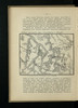
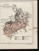
158. Plotnost' naselenija

1887. Nejbjurger, Fed. Iv. Russland and Moskau. Bevölkerungsdichte and Statistik. 1887/1887. Ethnografie. Versteckte Karten.
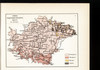
159. Plotnost' naselenīja ozernoj oblasti

1900. Moračevskij, V. Russland and Russland (Nord). Bevölkerungsdichte. Ethnografie. Versteckte Karten.
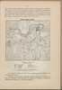
160. Podrazdelenie ploščadi Moskvy na pojasa, časti i učastki
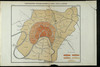
1887. Nejbjurger, Fed. Iv. Russland and Moskau. Stadtviertel and Statistik. 1887/1887. Versteckte Karten.