Search Constraints
1 - 83 of 83
Search Results
1. Albanie (Races et Religions)
1915. Albanien. Ethnische Gruppe and Denomination <Religion>. 1915/1915. Ethnografie. Versteckte Karten.
2. [Bălgarska zemja v Makedonija]
1915. Makedonien. Ethnische Gruppe and Bulgaren. Ethnografie. Versteckte Karten.
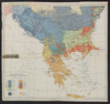
3. Carte ethnographique de la Macédoine, de l'Èpire et de la Thrace (1912)
1919. Makedonien <Landschaft>, Thrakien, and Epirus. Ethnische Gruppe. 1912/1912. Versteckte Karten.
4. Carte ethnographique de la Macédoine, Point de vue bulgare
1914. Makedonien. Ethnische Gruppe. 1913/1913. Ethnografie. Versteckte Karten.
5. Carte ethnographique de la Macédoine, Point de vue serbe
1914. Makedonien. Ethnische Gruppe. 1913/1913. Ethnografie. Versteckte Karten.
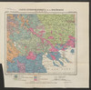
6. Carte ethnographique de la péninsule des Balkans
1918. Balkanhalbinsel and Südosteuropa. Ethnische Gruppe. Ethnografie. Versteckte Karten.
7. Das Deutschtum II. 1.
1912. Baltikum. Ethnische Gruppe and Deutsche. Ethnografie. Versteckte Karten.
8. Das Deutschtum II. 2.
1912. Schwarzmeer-Gebiet. Ethnische Gruppe and Deutsche. Ethnografie. Versteckte Karten.
9. Das Deutschtum in Europa
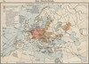
1912. Europa. Ethnische Gruppe and Deutsche. Ethnografie. Versteckte Karten.
10. Das Deutschtum in Europa
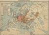
1912. Europa. Ethnische Gruppe and Deutsche. Ethnografie. Versteckte Karten.
11. Ethnographical map of Hungary based on the density of population
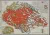
1922. Teleki, Pál. Ungarn. Ethnische Gruppe and Teleki, Pál. 1922/1922. Ethnografie.
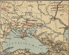
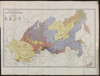
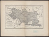
12. Ethnographische Übersichtskarte der Ukraina
1915. Ukraine. Ethnische Gruppe. Ethnografie. Versteckte Karten.
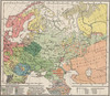
13. Ethnographische Übersichtskarte von Osteuropa
1916. Russland and Ukraine. Ethnische Gruppe. Ethnografie. Versteckte Karten.
14. Ethnographische Karte der europäischen Türkei und ihrer Dependenzen zu Anfang des Jahres 1877

1878. Sax, Carl. Südosteuropa. Ethnische Gruppe. 1877/1877. Ethnografie. Versteckte Karten.
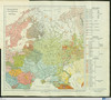
15. Ethnographische Karte des Asiatischen Russlands
1874. Russland and Russland / Asiatischer Teil. Ethnische Gruppe. Ethnografie. Versteckte Karten.
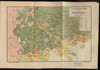
16. Ethnographische Karte des St. Petersburgischen Gouvernements

Keppen, Petr I. Gouvernement Sankt Petersburg. Ethnische Gruppe and Bevölkerung. Ethnografie.
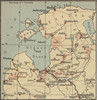
17. Ethnographische Karte von Litauen

1917. Litauen. Ethnische Gruppe. Ethnografie. Versteckte Karten.
18. Ethnographische Uebersicht nach überwiegenden Siedlungsverhältnisse

1918. Auner, H. Polen, Chełm (Województwo), and Podlachien. Ethnische Gruppe. Ethnografie. Versteckte Karten.
19. Ethnographische Uebersicht nach den Bezirksdurchschnitten

1918. Auner, H. Polen, Chełm (Województwo), and Podlachien. Ethnische Gruppe. Ethnografie. Versteckte Karten.
20. Etnografska karta na Makedonija
1915. Makedonien. Ethnische Gruppe. Ethnografie. Versteckte Karten.
21. Izvod ot etnografskata karta na Ležana

1915. Makedonien. Ethnische Gruppe. Ethnografie. Versteckte Karten.
22. Izvod ot etnografskata karta na Mekenzi i Erbi

1915. Makedonien. Ethnische Gruppe. Ethnografie. Versteckte Karten.
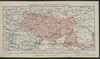
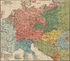
23. Karte III: Nationalitätenkarte von Österreich-Ungarn

1916. Österreich-Ungarn. Ethnische Gruppe. Ethnografie.
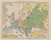
24. Karte V: Nationalitätenkarte von Europa

1916. Europa. Ethnische Gruppe. Ethnografie.
25. Map 1 : A part of Müller’s sketch map
2021. Demeter, Gábor and Bottlik, Zsolt. Kosovo. Ethnische Gruppe. 1844/1844. Ethnografie. Versteckte Karten.
26. Map 14a : Kaza-level ethnographic map of Tuna and Edirne Vilayets after 1831
2021. Demeter, Gábor and Bottlik, Zsolt. Vilâyet Edirne and Donau-Wilajet. Ethnische Gruppe. 1831. Ethnografie. Versteckte Karten.
27. Map 14b : Kaza-level ethnographic map of Macedonian Vilayets after 1831
2021. Demeter, Gábor and Bottlik, Zsolt. Makedonien (Landschaft). Ethnische Gruppe. 1831. Ethnografie. Versteckte Karten.
28. Map 15 : Ethnic map of Macedonia prior to 1878 (Extrait)
2021. Demeter, Gábor and Bottlik, Zsolt. Makedonien (Landschaft). Ethnische Gruppe. 1878. Ethnografie. Versteckte Karten.
29. Map 16 : Ethnographic map of North-Macedonia (Kosovo Vilayet) before 1878 (Austrian version)
2021. Demeter, Gábor and Bottlik, Zsolt. Kosovo. Ethnische Gruppe. 1878. Ethnografie. Versteckte Karten.
30. Map 17 : Ethnic map of South-Macedonia prior to 1878 (English version)
2021. Demeter, Gábor and Bottlik, Zsolt. Makedonien (Landschaft). Ethnische Gruppe. 1878. Ethnografie. Versteckte Karten.
31. Map 18 : Ethnic map of South-Macedonia in 1903 (Ottoman version)
2021. Demeter, Gábor and Bottlik, Zsolt. Makedonien (Landschaft). Ethnische Gruppe. 1903/1903. Ethnografie. Versteckte Karten.
32. Map 19 : Ethnic map of Macedonia prior to 1878 (based on the Ottoman census)
2021. Demeter, Gábor and Bottlik, Zsolt. Makedonien (Landschaft). Ethnische Gruppe. 1878. Ethnografie. Versteckte Karten.
33. Map 20 : Ethnic map of Macedonia prior to 1881 (based on the Ottoman census)
2021. Demeter, Gábor and Bottlik, Zsolt. Makedonien (Landschaft). Ethnische Gruppe. 1881/1881. Ethnografie. Versteckte Karten.
34. Map 21 : Ethnographic patch map of Macedonia, cca 1878 (Austrian version – Sax)
2021. Bottlik, Zsolt. Makedonien (Landschaft), Kosovo, and Vilâyet Yanya. Ethnische Gruppe. 1878/1878. Ethnografie. Versteckte Karten.
35. Map 22 : Ethnographic patch map of Macedonia, cca. 1900 (Austrian version)
2021. Demeter, Gábor and Bottlik, Zsolt. Makedonien (Landschaft), Kosovo, and Vilâyet Yanya. Ethnische Gruppe. 1900/1900. Ethnografie. Versteckte Karten.
36. Map 25 : Kaza-level ethnic pie chart map of Macedonia, cca. 1900 (Austrian version)
2021. Demeter, Gábor and Bottlik, Zsolt. Makedonien (Landschaft), Kosovo, and Vilâyet Yanya. Ethnische Gruppe. 1900/1900. Ethnografie. Versteckte Karten.
37. Map 28 : Ethnographic distribution of the population in Saloniki Vilayet (Gopčević, 1889)
2021. Demeter, Gábor and Bottlik, Zsolt. Selanik (Wilāyet) and Makedonien (Landschaft). Ethnische Gruppe. Ethnografie. Versteckte Karten.
38. Map 29 : Ethno-religious distribution of the population in Macedonia (based on Kănchov’s trip in 1894)
2021. Demeter, Gábor and Bottlik, Zsolt. Selanik (Wilāyet) and Makedonien (Landschaft). Ethnische Gruppe and Denomination (Religion). 1894/1894. Ethnografie. Versteckte Karten.
39. Map 30 : Ethnographic distribution of the population in Macedonia according to Nikolaides (1899)
2021. Demeter, Gábor and Bottlik, Zsolt. Selanik (Wilāyet) and Makedonien (Landschaft). Ethnische Gruppe. 1899/1899. Ethnografie. Versteckte Karten.
40. Map 31 : Ethnographic distribution of the population in Macedonia according to Ivanov (1912)
2021. Demeter, Gábor and Bottlik, Zsolt. Selanik (Wilāyet) and Makedonien (Landschaft). Ethnische Gruppe. 1912/1912. Ethnografie. Versteckte Karten.
41. Map 32 : Majority patch map of Macedonia from 1905 (Austrian)
2021. Bottlik, Zsolt. Selanik (Wilāyet) and Makedonien (Landschaft). Ethnische Gruppe and Mehrheit. 1905/1905. Ethnografie. Versteckte Karten.
42. Map 33 : Ethnic distribution of the Christian population according to R. von Mach (1906)
2021. Demeter, Gábor and Bottlik, Zsolt. Selanik (Wilāyet) and Makedonien (Landschaft). Ethnische Gruppe and Christ. 1906/1906. Ethnografie. Versteckte Karten.
43. Map 35 : Ethnic distribution of the population in Edirne Vilayet, cca. 1873
2021. Demeter, Gábor and Bottlik, Zsolt. Vilâyet Edirne. Ethnische Gruppe. 1873/1873. Ethnografie. Versteckte Karten.
44. Map 36 : Ethno-religious distribution of the urban population in Tuna and Edirne Vilayets, cca. 1874
2021. Demeter, Gábor and Bottlik, Zsolt. Vilâyet Edirne and Donau-Wilajet. Ethnische Gruppe and Stadtbevölkerung. 1874/1874. Ethnografie. Versteckte Karten.
45. Map 39 : Ethnic distribution of the urban population in Tuna Vilayet before 1878
2021. Demeter, Gábor and Bottlik, Zsolt. Donau-Wilajet. Ethnische Gruppe. 1878. Ethnografie. Versteckte Karten.
46. Map 45 : Ethnic distribution of the population in Edirne Vilayet, cca. 1881
2021. Demeter, Gábor and Bottlik, Zsolt. Vilâyet Edirne. Ethnische Gruppe. 1881/1881. Ethnografie. Versteckte Karten.
47. Map 46 : Ethnic distribution of the population in Kosovo Vilayet and the proportion of muhadjirs, cca. 1881
2021. Demeter, Gábor and Bottlik, Zsolt. Vilâyet Kosovo. Ethnische Gruppe and Muhāǧirūn. 1881/1881. Ethnografie. Versteckte Karten.
48. Map 47 : Ethnic distribution of the population in Seres Sanjak, cca. 1881 (Hondros)
2021. Demeter, Gábor and Bottlik, Zsolt. Serrä. Sandschak and Ethnische Gruppe. 1881/1881. Ethnografie. Versteckte Karten.
49. Map 48 : Ethnic distribution of the population in Seres Sanjak, cca. 1894 (Kănchov)
2021. Demeter, Gábor and Bottlik, Zsolt. Serrä. Sandschak and Ethnische Gruppe. 1894/1894. Ethnografie. Versteckte Karten.
50. Map 49 : Religious distribution of the population in Saloniki Vilayet in 1880
2021. Demeter, Gábor and Bottlik, Zsolt. Selanik (Wilāyet). Ethnische Gruppe. 1880/1880. Ethnografie. Versteckte Karten.
51. Map 5 : Ethnographic distribution of the population of Macedonia
2021. Demeter, Gábor and Bottlik, Zsolt. Makedonien (Landschaft). Ethnische Gruppe. 1878/1878. Ethnografie. Versteckte Karten.
52. Map 50 : Ethnic distribution of the population in Dobrudja before 1878
2021. Bottlik, Zsolt. Dobrudscha. Ethnische Gruppe. 1878. Ethnografie. Versteckte Karten.
53. Map 52 : Settlement-level ethnic map of southern Macedonia (Ivanov, cca. 1910)

2021. Bottlik, Zsolt. Makedonien (Landschaft). Ethnische Gruppe. 1910/1910. Ethnografie. Versteckte Karten.
54. Map 54 : Ethnic distribution of the population in Dobrudja according to Ionesco (Romanian, 1852)
2021. Demeter, Gábor and Bottlik, Zsolt. Dobrudscha. Ethnische Gruppe. 1852/1852. Ethnografie. Versteckte Karten.
55. Map 55 : Ethnic distribution of the urban population in Northern Bulgaria (Russian, 1877)
2021. Demeter, Gábor and Bottlik, Zsolt. Donau-Wilajet and Bulgarien. Ethnische Gruppe. 1877/1877. Ethnografie. Versteckte Karten.
56. Map 56 : Sketch map on the ethnic distribution of the population in Albania (cca. 1912)
2021. Demeter, Gábor and Bottlik, Zsolt. Vilâyet Yanya and Albanien. Ethnische Gruppe. 1910/1910. Ethnografie. Versteckte Karten.
57. Map 57 : The boundaries and ethnic contact zone of the Albanian nation (Ottoman version, 1908)
2021. Demeter, Gábor and Bottlik, Zsolt. Albanien, Kosovo, and Nordmazdonien. Ethnische Gruppe and Grenzgebiet. 1908/1908. Ethnografie. Versteckte Karten.
58. Map 58 : The boundaries and ethnic contact zone of the Albanian nation (Austria-Hungary, 1917)
2021. Demeter, Gábor and Bottlik, Zsolt. Albanien, Kosovo, and Nordmazdonien. Ethnische Gruppe and Grenzgebiet. 1917/1917. Ethnografie. Versteckte Karten.
59. Map 59 : The boundaries and ethnic contact zone of the Albanian nation (Bulgarian version, 1918)
2021. Demeter, Gábor and Bottlik, Zsolt. Albanien, Kosovo, and Nordmazdonien. Ethnische Gruppe and Grenzgebiet. 1918/1918. Ethnografie. Versteckte Karten.
60. Map 6 : A simplified ethnic map of the Balkans for Hungarian military officers
2021. Demeter, Gábor and Bottlik, Zsolt. Balkanhalbinsel. Ethnische Gruppe. 1913/1913. Ethnografie. Versteckte Karten.
61. Map 60 : Ethnographic data on Albania and the sanjak of Novipazar according to Roukis (1884)
2021. Demeter, Gábor and Bottlik, Zsolt. Albanien and Sandschak Novi Pazar. Ethnische Gruppe. 1884/1884. Ethnografie. Versteckte Karten.
62. Map 61 : Ethnic map of the Balkans in 1910 (based on Ottoman salname)
2021. Demeter, Gábor and Bottlik, Zsolt. Balkanhalbinsel. Ethnische Gruppe. 1910/1910. Ethnografie. Versteckte Karten.
63. Map 8 : a simplified sketch map of the evolution of Cvijic’s ideas
2021. Demeter, Gábor and Bottlik, Zsolt. Balkanhalbinsel. Ethnische Gruppe and Cvijić, Jovan. Ethnografie. Versteckte Karten.
64. Map 9 : The ethnic map of Chekrezi, on the southern border of Albania, in 1913
2021. Demeter, Gábor and Bottlik, Zsolt. Albanien, Griechenland, and Nordmazedonien. Ethnische Gruppe and Çekrezi, Kostë A. 1913/1913. Ethnografie. Versteckte Karten.
65. Mitteleuropa. Völker

1912. Mitteleuropa. Ethnische Gruppe. Ethnografie. Versteckte Karten.
66. [Nebenkarte Kreta] Ethnographische Karte der europäischen Türkei und ihrer Dependenzen zu Anfang des Jahres 1877
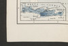
1878. Sax, Carl. Griechenland and Kreta. Ethnische Gruppe. 1877/1877. Ethnografie. Versteckte Karten.
67. Plemena ozernoj oblasti
1900. Stavrovskij, Ja. Russland and Russland (Nord). Ethnische Gruppe. Ethnografie. Versteckte Karten.
68. Plemena srednerusskoj černozemnoj oblasti
1902. Russland and Zentralrussland. Ethnische Gruppe. Ethnografie. Versteckte Karten.
69. [Serben]
1915. Makedonien. Ethnische Gruppe and Serben. Ethnografie. Versteckte Karten.
70. Österreich-Ungarn. Völker

1912. Österreich-Ungarn. Ethnische Gruppe. Ethnografie. Versteckte Karten.
71. Types et variétés psychiques des Yougoslaves
1918. Balkanhalbinsel and Südosteuropa. Ethnische Gruppe. Ethnografie. Versteckte Karten.
72. Ukraine. Ethnographische Karte des einheitlichen ukrainischen Gebiets ohne Enklaven
1915. Ukraine. Ethnische Gruppe. Ethnografie. Versteckte Karten.
73. Völkerkarte

1913. Österreich-Ungarn. Ethnische Gruppe. Ethnografie. Versteckte Karten.
74. Völkerkarte

1913. Balkanhalbinsel. Ethnische Gruppe. Ethnografie. Versteckte Karten.
75. Völkerkarte

1913. Österreich-Ungarn. Ethnische Gruppe. Ethnografie. Versteckte Karten.
76. Völkerkarte

1913. Südosteuropa. Ethnische Gruppe. Ethnografie. Versteckte Karten.
77. Völkerkarte
1913. Osteuropa. Ethnische Gruppe. Ethnografie. Versteckte Karten.
78. Völkerkarte von Europa
1893. Europa. Ethnische Gruppe. Ethnografie. Versteckte Karten.
79. Völkerkarte von Europa

1912. Europa. Ethnische Gruppe. Ethnografie. Versteckte Karten.
80. Völkerkarte von Europa

1912. Europa. Ethnische Gruppe. Ethnografie. Versteckte Karten.
81. Völkerkarte von Mitteleuropa
1912. Mitteleuropa. Ethnische Gruppe. Ethnografie. Versteckte Karten.
82. [Zemlě u koima prebivaju Srbjui]
1915. Makedonien. Ethnische Gruppe and Serben. Ethnografie. Versteckte Karten.
83. Zones de civilisation
1918. Balkanhalbinsel and Südosteuropa. Ethnische Gruppe. Ethnografie. Versteckte Karten.