Search Constraints
You searched for:
Map Type
Bevölkerungskarte
Remove constraint Map Type: Bevölkerungskarte
Search Results
191. Map 61 : Ethnic map of the Balkans in 1910 (based on Ottoman salname)
2021. Demeter, Gábor and Bottlik, Zsolt. Balkanhalbinsel. Ethnische Gruppe. 1910/1910. Ethnografie. Versteckte Karten.
192. Map 8 : a simplified sketch map of the evolution of Cvijic’s ideas
2021. Demeter, Gábor and Bottlik, Zsolt. Balkanhalbinsel. Ethnische Gruppe and Cvijić, Jovan. Ethnografie. Versteckte Karten.
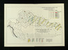
193. Map 9 : The ethnic map of Chekrezi, on the southern border of Albania, in 1913
2021. Demeter, Gábor and Bottlik, Zsolt. Albanien, Griechenland, and Nordmazedonien. Ethnische Gruppe and Çekrezi, Kostë A. 1913/1913. Ethnografie. Versteckte Karten.
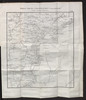
194. Materinski jezik građanskog žiteljstva 1910 po upravnim kotarima i gradovima
1915. Kroatien and Slawonien. Muttersprache and Statistik. 1910/1910. Ethnografie. Versteckte Karten.
195. Mineralien
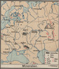
1913. Russland / Europäischer Teil. Mineralischer Rohstoff. Versteckte Karten.
196. Mitteleuropa: Konfessionsgebiete
1912. Mitteleuropa. Denomination <Religion>. Versteckte Karten.
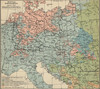
197. Mitteleuropa. Völker

1912. Mitteleuropa. Ethnische Gruppe. Ethnografie. Versteckte Karten.
198. Mitteleuropa Volksdichte

1888. Mitteleuropa. Bevölkerungsdichte. Versteckte Karten.
199. Mittlerer Theil des Saratowschen Gouvernements mit den deutschen Colonieen
1825. Russland and Saratow (Gouvernement). Wolgadeutsche. 1825/1825. Migration. Versteckte Karten.
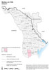
200. Moldau um 1930. Albaner
2005. Hofinger, Veronika. Moldawien. ethnische Gruppe and Albaner. 1930/1930. Ethnografie. Versteckte Karten.