Search Constraints
You searched for:
Map Type
Geschichtskarte
Remove constraint Map Type: Geschichtskarte
License
Copyright
Remove constraint License: Copyright
« Previous |
1 - 20 of 116
|
Next »
Search Results
1. Map 13a : Kaza-level administrative map of Tuna and Edirne Vilayets after 1878
2021. Demeter, Gábor and Bottlik, Zsolt. Vilâyet Edirne and Donau-Wilajet. Verwaltungsgliederung. 1878. Ethnografie. Versteckte Karten.
2. Map 13b : Kaza-level administrative map of Macedonian vilayets after 1900
2021. Demeter, Gábor and Bottlik, Zsolt. Albanien, Kosovo, and Mazedonien. Verwaltungsgliederung. 1900. Ethnografie. Versteckte Karten.
3. Map 26 : Christian schools in Macedonia, cca. 1900
2021. Bottlik, Zsolt. Makedonien (Landschaft), Kosovo, and Vilâyet Yanya. Bekenntnisschule. 1900/1900. Ethnografie. Versteckte Karten.
4. Map 27 : Churches and schools in Macedonia, cca. 1900 (based on Phocas-Cosmetatos)
2021. Bottlik, Zsolt. Selanik (Wilāyet). Bekenntnisschule and Kirche. 1900/1900. Ethnografie. Versteckte Karten.
5. Map 4 : The plan of Calice (Austrian ambassador to Constantinople) from 1896
2021. Demeter, Gábor and Bottlik, Zsolt. Balkanhalbinsel. Großmachtpolitik and Calice, Heinrich von. 1896/1896. Ethnografie. Versteckte Karten.
6. Map 40 : Significance and central function of towns in Tuna Vilayet, 1876
2021. Demeter, Gábor and Bottlik, Zsolt. Donau-Wilajet. Stadt and Raumordnung. 1876/1876. Ethnografie. Versteckte Karten.
7. Map 41 : Churches and mosques in the towns of Tuna Vilayet, 1876
2021. Demeter, Gábor and Bottlik, Zsolt. Donau-Wilajet. Kirche and Moschee. 1876/1876. Ethnografie. Versteckte Karten.
8. Map 42 : Inns (han) and baths (hamam) in the towns of Tuna Vilayet, 1876
2021. Demeter, Gábor and Bottlik, Zsolt. Donau-Wilajet. Karawanserei and Hammam. 1876/1876. Ethnografie. Versteckte Karten.
9. Map 43 : Stores and bazaar shops in the towns of Tuna Vilayet, 1876
2021. Demeter, Gábor and Bottlik, Zsolt. Donau-Wilajet. Laden and Basar. 1876/1876. Ethnografie. Versteckte Karten.
10. Map 57 : The boundaries and ethnic contact zone of the Albanian nation (Ottoman version, 1908)
2021. Demeter, Gábor and Bottlik, Zsolt. Albanien, Kosovo, and Nordmazdonien. Ethnische Gruppe and Grenzgebiet. 1908/1908. Ethnografie. Versteckte Karten.
11. Map 58 : The boundaries and ethnic contact zone of the Albanian nation (Austria-Hungary, 1917)
2021. Demeter, Gábor and Bottlik, Zsolt. Albanien, Kosovo, and Nordmazdonien. Ethnische Gruppe and Grenzgebiet. 1917/1917. Ethnografie. Versteckte Karten.
12. Map 59 : The boundaries and ethnic contact zone of the Albanian nation (Bulgarian version, 1918)
2021. Demeter, Gábor and Bottlik, Zsolt. Albanien, Kosovo, and Nordmazdonien. Ethnische Gruppe and Grenzgebiet. 1918/1918. Ethnografie. Versteckte Karten.
13. I. Brǎila. Umlandkarte
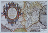
2013. Castaldo, Jacobo and Ortelius, Abraham. Rumänien. 1584/1584. Versteckte Karten.
14. II. Brǎila. Umlandkarte
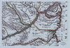
2013. Sanson, Nicolas. Brǎila. 1690/1690. Versteckte Karten.
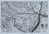
15. III. Brǎila. Umlandkarte
2013. Ruhedorf, Ferdinand Joseph. Brǎila. 1790/1790. Versteckte Karten.
16. IV. Brǎila. Umlandkarte
2013. Velestinlis, Rigas. Brǎila. 1796/1797. Versteckte Karten.
17. V. Brǎila. Umlandkarte

2013. Brǎila. 1812/1812. Versteckte Karten.
18. VI. Brǎila. Umlandkarte

2013. Popp de Szathmáry, Carol. Brǎila. 1864/1864. Versteckte Karten.
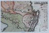
19. XIX. Brǎila. Erweiterungsetappen der Stadt
2013. Brǎila. Stadtentwicklung. 1300/2010. Versteckte Karten.
20. Besetzung und territoriale Aufteilung Jugoslawiens im Zweiten Weltkrieg
2011. Clewing, Konrad and John, Holger W. Jugoslawien. Besetzung and Weltkrieg <1939-1945>. 1941/1945. Militärgeschichte. Versteckte Karten.