Search Constraints
You searched for:
Map Type
Landnutzungskarte
Remove constraint Map Type: Landnutzungskarte
Map Scale
100000
Remove constraint Map Scale: 100000
1 entry found
Search Results
1. Kultur- und Waldbestandskarte des Nordwest-Bachern
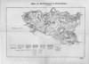
1935. Bacher. Bewaldung. Versteckte Karten.