Search Constraints
Search Results
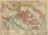
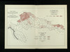
81. Österreich-Ungarn. Industrie und Verkehrswege

1912. Österreich-Ungarn. Industrie and Verkehrsnetz. Versteckte Karten.
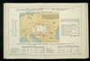
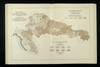
82. Österreich-Ungarn. Landwirtschaft

1911. Österreich-Ungarn. Landwirtschaft. Versteckte Karten.
83. Österreich-Ungarn. Landwirtschaft und Fischerei
1912. Österreich-Ungarn. Landwirtschaft and Fischerei. Versteckte Karten.
84. Tartlau : Flureinteilung (nach Csallner, vereinfacht)
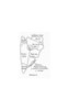
1934. Prejmer . Versteckte Karten.
85. Šume 1914. po upravnim kotarima i gradovima
1915. Kroatien and Slawonien. Statistik and Statistik. 1914/1914. Ethnografie. Versteckte Karten.
86. Uvoz robe i vrijednost za proiyvodnju upotrebljenih sirovina, polutvorina i tvorina kod većih tvornica 1912. Kralj. Hrvatska i Slavonija
1915. Kroatien and Slawonien. Import and Statistik. 1912/1912. Versteckte Karten.
87. Verteilung der Industrien im Burzenlande

1934. Burzenland. Produzierendes Gewerbe. Versteckte Karten.
88. Vinogradi 1914. po upravnim kotarima i gradovima
1915. Kroatien and Slawonien. Statistik and Statistik. 1914/1914. Ethnografie. Versteckte Karten.
89. Vjeresijski zavodi 1913. po upravnim kotarima i gradovima
1915. Kroatien and Slawonien. Verbreitungskarte and Statistik. 1913/1913. Ethnografie. Versteckte Karten.
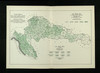
90. Vodene snage u Jugpslaviji ( Veće projektirane hidro-električne centrale)
1924. Božidar, Prikril. Jugoslawien. Wasserkraft.