Search Constraints
You searched for:
Keyword
Versteckte Karten
Remove constraint Keyword: Versteckte Karten
Data Type
Raster
Remove constraint Data Type: Raster
Publication Year
1899
Remove constraint Publication Year: 1899
1 - 5 of 5
Search Results
1. Map illustrating ancient Russian history
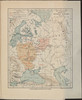
1899. Philip, George and Philip, [Sohn v. G.]. Russland and Kiewer Reich. Versteckte Karten.
2. Map of the Amur Region
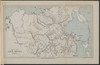
1899. Philip, George and Philip, [Sohn v. G.]. Russland, Sibirien, and Amur. Versteckte Karten.
3. Map of the conquest of Siberia
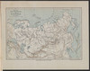
1899. Philip, George and Philip, [Sohn v. G.]. Russland and Sibirien. Eroberung. 1582/1582. Militärgeschichte. Versteckte Karten.
4. Map showing the communications between the Ob and Yenissei Rivers

1899. Sibirien, Ob, and Jenissei. Flusssystem. Versteckte Karten.
5. Map showing the communications between the Yenissei and Lena Rivers

1899. Sibirien, Lena, and Jenissei. Flusssystem. Versteckte Karten.